
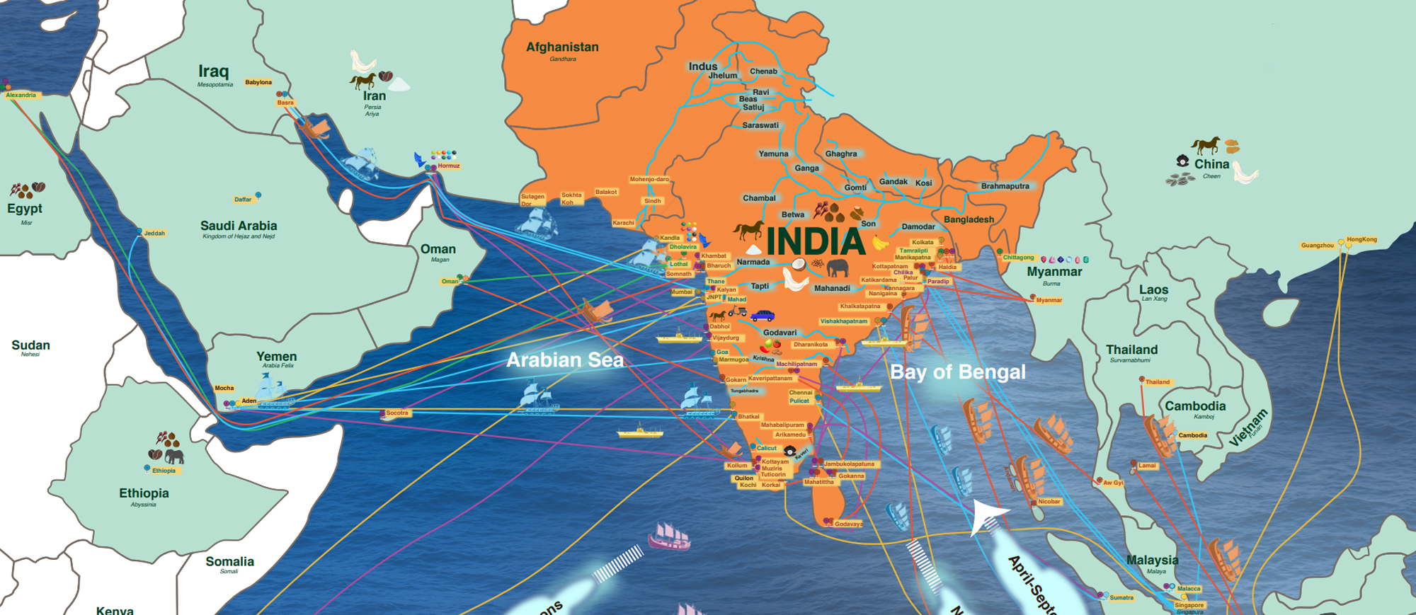
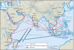
India has a long tradition of indigenous seafaring which is well attested from the late chalcolithic period to the late medieval period. Seafaring in India was a continuing practice contrary to the edicts of the Manusmriti That prohibited the crossing of seas especially those by Brahmins. Seafarers became the conduit through which Indian culture and religious traditions seeped into territories beyond the frontiers.
Some of the earliest seafaring people in the recorded history of the Indian subcontinent were the Harappans. The Harappans were noted to have constructed large citadels with well laid urban settlements unparalleled in the ancient world. But the discovery of Lothal and Dholavira unravelled a different dimension of this chalcolithic culture. The excavation of a dry dock at Lothal and a fortified island city of Dholavira put the Harappans on the ancient maritime map. Both Lothal and Dholavira were among the Harappan coastal settlements which were major nodal points associated with the coastal navigation undertaken by the Harappan seafarers. These cities produced drilled beads especially carnelian which are endemic to the Gujarat region and were in great demand in the Mesopotamian markets.
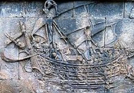
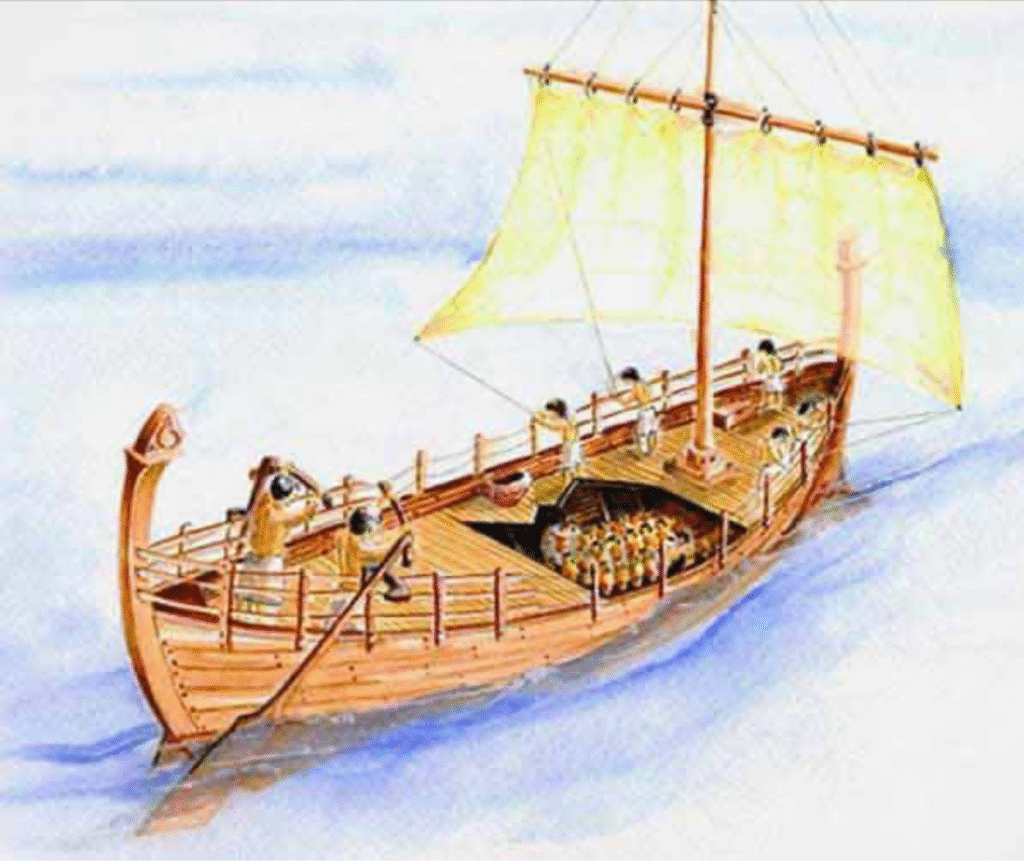
The Harappan seafarers who inhabited the outlier areas/ coastal areas of the Harappan cultural expanse used the coasting method of navigation to sail in the waters of the Makran coast and Persian Gulf area. The voyages were undertaken with the help of a canoe-like boat made from reeds, bound together to give buoyancy. The boats were often fitted with a mast from which a primitive sail were fixed to provide propulsion. In addition to the sails, paddles were used to propel the boat as shown in the Harappan steatite seals. In one conspicuous depiction of the Harappan boat, two crow-like birds are shown perched on the prow of the boat. These birds are the famed disa kaka or direction crows used by sailors in mid sea to locate land when found lost at sea. Besides the Harappan archaeological finds, in the Rigveda the hymns dedicated to the Ashvins mentions a marine voyage undertaken by Prince Bhujyu to defeat his foes across the seas. In this expedition, his ship was destroyed in a storm mid sea from which he was later saved by seafarers who used a ship with a hundred oars. This account of the Rigveda is one of the earliest mentions of oceanic voyage in the world.
In the Buddhist canon there are several depictions of seafarers. The sea routes that they sailed through are also
well attested in history for example the route to Baveru, the ancient Babylon was well known to the Harappan
seafarers. The eastern route to Suvarnabhumi, the insular nations of southeast Asia were also accessible many
centuries before the common era.
Indigenous seafaring continued even in the early medieval period. The Indian coast was brimming with
maritime activity from Somanatha in the west to Tamralipti in the east. The pepper trade, still being a
profitable venture, attracted foreign seafarers to the Malabar coast. Malabar then was the only pepper
producing centre in the world. Thus monopolizing the market of this valuable commodity. Trade guilds also called as shrenis operated in a wide network in the Indian Ocean rim region and places as far as Quanzhou on the South China sea coast. These guilds connected the Indian hinterland with the global
market. The most prominent of these guilds was the Aihole five hundred also called the Ainnurruvar. The Ainnuruvar was a guild of merchants incorporated in the city of Aihole, Karnataka by a collective of five hundred brahmins, which over time admitted persons of other castes to form a cosmopolitan group of seafaring merchants.
EARLY SEAFARING IN THE INDIAN OCEAN REGION
Early Deep Water sailing in the Indian Ocean is attributed to Astronomical, Geographical and Meteorological
reasons:
Astronomically, the progenitors of the early civilization including Indians whose knowledge of the heavenly
bodies was well advanced. Their knowledge of heavenly bodies might have, in all probability, enabled them to
take to a sea-career early.
From the Geographical point of view the Indian Ocean takes a gigantic bay-form enclosed on three sides by
land. Land-routes existed along the coastline suggesting naval development when man could undertake it.
Meteorologically the knowledge of the periodical winds was the greatest incentive to deep, distant sailing. A seaworthy floating instrument, acquaintance with the heavenly bodies, the knowledge of winds, a piece of canvas and adventurous spirit must have prompted seaman of the Indian Ocean to take to navalism at an early date. All these points of vantage are applicable to the Arabs as well as to the Indians. Neither the Atlantic nor the Pacific have had these advantages.
VEDIC & PRE-ASHOKA PERIOD
The earliest references to the navigational activities of our people are to be found in the Rigveda. The words indicative of these activities are nau (boat), shataritram navam (a hundred-oared boat), samudra (sea or expanse of water), and navah samudriyah paths of the boats in the sea). The reference to a hundred-oared ship presumes knowledge of ship-building and navigation. They used the word samudra for the vast expanse of water they came across in the region of the Seven Rivers – Sapta Sindhu. Besides the Rigveda, the Shatapatha Brahmana, the Mahabharata, the Ramayana, the Manusmriti and the Puranas afford evidence regarding the maritime activities of our ancestors. Similarly, references to sea-trade and sea-voyage are available in the Mahabharata. The Manusmriti includes naval fights in the discussion on warfare in general. The Arthashastra of Kautilya while describing the duties of the navadhyaksa – the superintendent of ships – gives a brief account of navigation. It was the duty of the superintendent of ships to inspect the accounts concerning navigation on the sea, the estuaries, the lakes natural as well as artificial, and the rivers. Varying duties were levied on different articles transported on board the ships. The fisheries and passengers had also to pay taxes. The large ships are called mahanavah and were provided with a shasaka – captain
– Niyamaka – steersman, and also with men who worked at the cordage and baled out water
LOTHAL & DHOLAVIRA – The World’s First DOCK & PORT
The world’s first dock at Lothal (2400 BCE) was located away from the main current to avoid deposition of silt. Modern oceanographers have observed that the Harappans must have possessed great knowledge relating to tides in order to build such a dock on the ever-shiNing course of the Sabarmati as well as exemplary hydrography and maritime engineering. This was the earliest known dock found in the world, equipped to berth and service ships. It is speculated that Lothal engineers studied tidal movements, and their effects on brick-built structures, since the walls are of kiln-burnt bricks. This knowledge also enabled them to select Lothal’s location, as the Gulf of Khambhat has the highest tidal amplitude and ships can be sluiced
through flow tides in the river estuary.
The Mauryas | Chandragupta & Ashoka
The fragment of the eighth edict of Ashoka found near Sopara shows the extent of his kingdom on that side. Aparanta or North Konkan then enjoyed a sort of semi-independent position under the sovereign rule of Ashoka. This is the first definite reference in the history of Konkan. Chandragupta Maurya, the grand-father of Ashoka, had a well-organised state navy. Under Ashoka, the Maurya Empire reached the zenith of its glory. The sea–boards of Gujarat and North Konkan or Aparanta were under his sway. His kingdom spread from sea to sea, from the Western Sea to the Eastern Sea.
KALINGAS
Kalinga (3rd century BCE) established footholds in Malaya, Sumatra and Western Java. Maritime History of Odisha, known as Kalinga in ancient times, started before 350 BC according to early sources. The people of this region of eastern India along the coast of the Bay of Bengal sailed up and down the Indian Coast and travelled to Indo China and throughout Maritime South east Asia introducing elements of their culture to the people they traded with. The old traditions are still celebrated in the annual Bali Yatra or Boita Bandana festival held for five days in October/November.
SATAVAHANAS
When Rome ruled the Western world, and the Satavahanas the Deccan, trade between India and Rome was brisk and voluminous. Number of Roman coins are found in the southern and the western parts of India, some of them bearing the stamp of Augustus Caesar. Indians are reported to have sailed as far as Alexandria. They often visited the island of Socotra at the mouth of the Red Sea. Greek ships came to the ports of Broach, Sopara and Kalyan. Coins of Satavahana Pulumavi II with the impress of a two-masted ship have been found on the Coromandal coast. They bear witness to the maritime activities of the Satavahanas.
CHALUKYAS
The Chalukyas ruled from about A.D. 500 to A.D. 753 with its capital at Vatapipura i.e. modern Badami in Bijapur district. The rulers of this house aspired for the sovereignty of the Deccan. The fame of Pulakesi II spread beyond the ocean. The Persian Prince Chosroas II (A.D. 571 to A.D. 628) who was his contemporary sent an embassy to the court of Pulakesi II. Probably, this embassy was sent by sea in view of the fact that the searoute was shorter and easier than the land-route which passed through the territory of Harsha who coveted the kingdom of Pulakesi II.
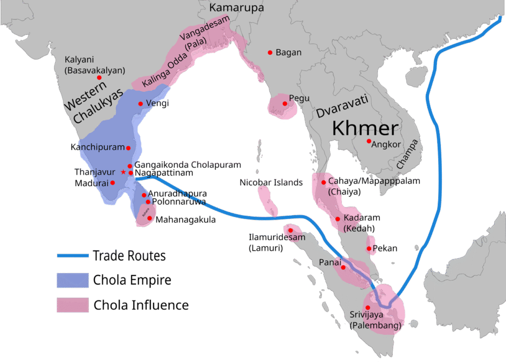
CHOLAS
The Chola dynasty (300 BC—1279 AD) reached the peak of its influence and power during the medieval period.
Emperors Rajaraja Chola (reigned 985–1014) and Rajendra Chola I (reigned 1012–1044) extended the Chola
kingdom beyond the traditional limits. At its peak, the Chola Empire stretched from the island of Sri Lanka in
the south to the Godavari basin in the north. The kingdoms along the east coast of India up to the river Ganges
acknowledged Chola suzerainty. Chola navies invaded and conquered Srivaijaya the largest empire in Maritime
Southeast Asia. Goods and ideas from India began to play a major role in the “Indianization” of the wider world
from this period. The Cholas excelled in foreign trade and maritime activity, extending their influence overseas to China and Southeast Asia.
EXPORTS & IMPORTS OF THE DECCAN IN ANCIENT TIMES
The Chief Exports of the Deccan – Cotton–yarn and cloth both rough and fine, muslins, coconuts, sandal and
teak-wood, sesame-oil, ivory, etc. were the main articles of export. Out of these, indigo, hides, perfume,
coconuts and teak-wood were the products of Konkan. It also included rice. Kalyan was the chief port for the
exports of northern Konkan. In the 5me of Marco Polo, Thana used to import gold, silver and copper. Horses
were imported in large numbers, as they were constantly demanded by the warring princes of the
Deccan. No ship probably came from Arabia or the Persian Gulf to the ports of Konkan without horses.
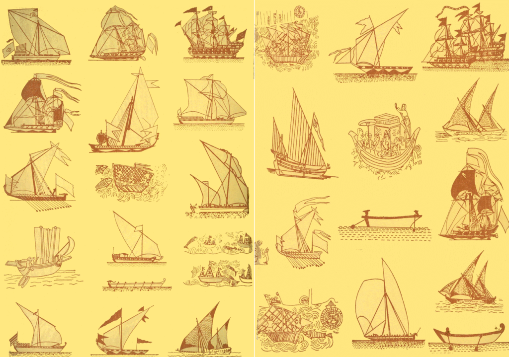
THE SHIPS OF YUKTIKALPATARU | EARLIEST SHIP BUILDING MANUAL!
Yukti Kalpataru is a famous treatise in Sanskrit principally on ship building in ancient Hindu world. It was
written and compiled by King Bhoja (C 1000 – 1055 CE) of the Paramara dynasty. There are references to
shipping and shipbuilding in other languages of the world but Yukti Kalpataru is the oldest book which deals
with shipbuilding in such exhaustive detail. Apart from Shipping, Yuktikalpataru also touches upon many other
topics like selection of jewels, swords, horses, elephants, ornaments, flags and so on.
The book begins with the selection of wood for building boats and ships. The ships are built using light andhard
and this type of wood cannot be joined with other types of woods like soft and heavy or hard and heavy or
light and soft. Ships made of other types of wood are not good and do not last long. They rot in water early and are liable to split at the slightest shock. The treatise gives an elaborate classification of ships based on size. There are ordinary ships that are used to travel in rivers and special ships which are used in the ocean. Under the ordinary class are ten types of ships and boats, differing in length, breadth, and height. Ocean-going vessels have two sub classes – dirgha, noted for length, having 10 varieties, unnata, noted for height rather than for dimensions!
INDIAN INDEPENDENCE & THE NAVAL MUTINY
Indians even owe their Independence from British Rule to the Arabian Sea, Bay of Bengal, Indian Ocean and the Navy! It is widely accepted that the real reason for Bri5sh relinquishing its colony, Jewel in The Crown, India was the Naval Mutiny in Bombay! ANer they found that the Defence Forces that they controlled with an iron hand was now out of their control and it would be difficult to rule the sub-continent without the support of its army & navy! The mutiny started on February 18, 1946. Indians from a wide range of backgrounds and occupations, including labourers, farmers, and others, soon joined in support of the revolt. Over 20,000 sailors were eventually involved in the uprising, which began in Bombay and eventually extended
and received support across British India, from Karachi to Calcutta. More than 78 ships and shore-based establishments were involved. British India lost command of its navy in just 48 hours. Revolts spread across Calcutta, Karachi, Poona, Vizag, Cochin, Madras, Mandapam, and the Andaman Islands! The naval mutiny in 1946 significantly contributed to ensuring civilian supremacy over colonialism and it posed the ultimate challenge to the British government’s capability to command its military forces.
INDIAN NAVY
The Indian Navy is a multi-dimensional force that has been organized to safeguard India’s maritime territorial integrity and other maritime interests. It is headed by the Chief of the Naval Staff or the CNS. He is of the rank of Admiral and has his headquarters at New Delhi. The Indian Navy has two Operational Commands and one Training Command:
• The Western Naval Command at Mumbai
• The Eastern Naval Command at Visakhapatnam
• The Southern Naval Command is the Training Command at Kochi
The major bases of the Indian Navy are located at Mumbai, Goa, Karwar, Kochi, Chennai, Visakhapatnam, Kolkata and Port Blair. The biggest ships of the Indian Navy form part of its two Fleets. A Fleet is a group of ships that operate under one authority. The Indian Navy’s Western Fleet is based at Mumbai and the Eastern Fleet is based at Visakhapatnam. There are also Flotillas of ships, Squadrons of submarines and various types of aircraft operated by the Navy from a number of Naval Air Stations.
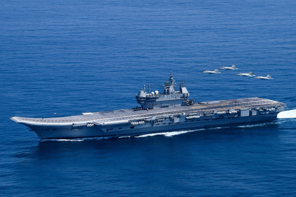
The Indian Navy’s present force level comprises about 150 ships and submarines. There are presently more than 50 ships and submarines under construction. In the South, Cochin Shipyard Limited (CSL) is progressing the construction of our most ambitious ship yet – the Indigenous Aircraft Carrier. At Mumbai, our premier warship-building yard Mazagon Docks Ltd, is engaged in the construction of Kolkata Class and P-15B destroyers besides stealth frigate of the Shivalik Class. Submarines of the Scorpene Class are also under construction at MDL. Goa Shipyard Limited, which has built a number of Offshore Patrol Vessels for the Navy and the Coast Guard, has advanced versions of this type under construction. (from Ministry of Defence Website)
INDIA’s MODERN PORTS
India has 13 major and 205 notified minor and intermediate ports. Under the National Perspective Plan for
Sagarmala, six new mega ports will be developed in the country. The Indian ports and shipping industry play a
vital role in sustaining growth in the country’s trade and commerce. India’s 95% of trading by volume is done
through maritime transport. It stands at 70% by value.
All ports in India are situated in the 9 coastal states of India – Kerala, Karnataka, Maharashtra, Goa, Gujarat,
West Bengal, Odisha, Andhra Pradesh, and Tamil Nadu. India’s extended coastline forms one of the major portions of land that juts out into a water body. Thirteen major ports in the country handle a lot of volume of container and cargo traffic.
On the west coast, there are the ports of Mumbai, Kandla, Mangalore, JNPT, Mormugao, and Cochin. The ones on the east coast are the ports at Chennai, Tuticorin, Visakhapatnam, Paradip, Kolkata, and Ennore. In Andaman and Nicobar Islands has Port Blair. Mumbai is the largest natural port in India.
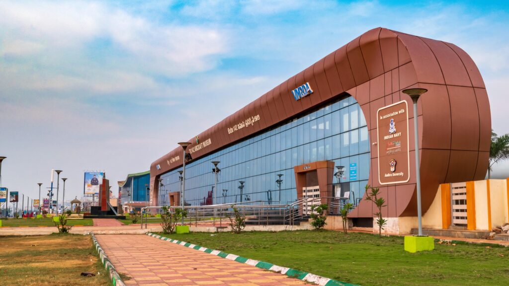
NAVAL MUSEUMS IN INDIA | PRESENT & UPCOMING
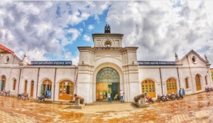
The Indian Naval Maritime Museum, also known as the Naval Museum, is a museum dedicated to the maritime history and heritage of the Indian Navy. It is located in the historic naval base of INS Dronacharya in Kochi, Kerala. The Indian Government has approved plans for a huge National Maritime Heritage Complex (NMHC) at Lothal in Gujarat, an inland archaeological port site from the Harappan era, now 30 miles from the sea. It is being billed as the biggest maritime heritage complex in the world.
List of some of the Maritime Museums in India
1. Odisha State Maritime Museum, Cuttack
2. Naval Aviation Museum, Bogmalo, Goa
3. Marine Museum, Navi Mumbai
4. INS Vikrant Naval Dockyard Museum, Mumbai
5. INS Kurusura, Submarine Museum, Vishakhapatnam
6. Naval Museum, Vishakhapatnam
7. Naval Marine Museum Samudrika, Port Bllair
8. National Maritime Museum, Mumbai